How To Find Your Property On FEMA’s Flood Insurance Rate Maps

What are FEMA flood maps?
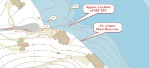
FEMA’s Flood Insurance Rate Maps (FIRMs) or just Flood Maps are provided after a flood risk assessment has been completed or updated for a community.  This study is known as a Flood Insurance Study.  The FIRM gives you the Base Flood Elevations (BFEs) and insurance risk zones in addition to floodplain boundaries.  The FIRM may also show a delineation of the regulatory floodway.

Once the “insurance risk zone”  (commonly referred to as the flood zone) is determined, actuarial rates, based on these risk zones, are then applied for newly constructed, substantially approved, and substantially damaged buildings.  FEMA uses these rates to determine the insurance rate you will pay for flood insurance

FEMA’s Digital Flood Maps

FEMA discontinued the production and distribution of paper flood maps in 2009 as part of its Digital Vision Initiative. This affected all the Flood Maps, boundary information, and study reports. However, clients can still view the products for free through their website or buy them in digital format.

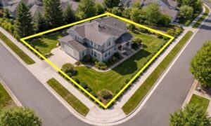
To view these flood maps online, go to FEMA’s Map Service Center and key in your address (hi-lited area shown here) search for your home.  This will prompt you to then select the map that covers your area.  The Flood Maps are somewhat cumbersome to use online. It is best to go through the tutorial on the bottom right of the address search page for an easier and more effective use of the GIS map.


author avatar
Surveyor

More Posts

House survey before a home renovation project
land surveying
Surveyor

What a House Survey Reveals Before You Start Renovation or Building

Home projects are picking up speed across Utah. From Salt Lake City to St. George, homeowners are pulling permits and calling contractors. Many skip one step first: the house survey. That’s a mistake. A survey shows you what’s really on your lot before anyone breaks ground. A house survey gives

Read More »
Professional land surveyor using GPS equipment on a residential development site, marking property boundaries with stakes during land surveying work
land surveyor
Surveyor

How a Land Surveyor Helps Buyers Make Confident Property Decisions

Utah’s real estate market is booming. New developments pop up every month. Property values climb. Competition between buyers intensifies. In this fast-paced environment, a land surveyor has become essential for developers and serious buyers who want to avoid expensive mistakes. A professional survey does more than confirm where your property

Read More »
Survey crew performing an as-built survey and site verification at a completed commercial property
land surveying
Surveyor

What Is an As-Built Survey and Why Banks and Cities Require It

After construction ends in Ogden, one document can determine whether your project gets approved, funded, or legally closed: the as-built survey. Most people have never heard of it. But if you are building, buying, or financing a property, it matters more than you might expect. What Is an As-Built Survey?

Read More »