Why You SHOULD Have a Land Survey Completed Before Purchasing Land?

Buying land, whether commercial or residential, is always an expensive endeavor, even if prices have eased somewhat lately. This is why finding a piece of land that you like and making an offer for it without conducting a land survey on the area is possibly the biggest mistake that you can make.

Here’s why it’s very important that you have land surveying done first:

Land surveyors can determine if you’re actually getting what you’re going to pay for. This means find out whether the sidewalks, trees, driveways and even the bird bath is part of the property you’re about to buy. Land surveying would also determine whether the neighbors are encroaching into the property, which would then mean you’re going to have problems in the future with your neighbors.
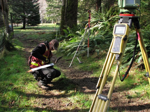
Land SurveyHiring a lamand surveyor doesn’t only mean they determine what you’re getting or not getting – land surveyors are the experts, and they can help with building regulations, wetland regulations, etc. Take note that these regulations can change anytime, but land surveyors should be updated on these regulations, or they will refer you to someone who is.

What if the current landowner (the one selling the land) can provide you with old land survey documents? You should still hire your own land surveyor to see if the boundary monuments are still in place. Also, land surveying done a few years back may not show recent changes to the land. If the existing survey is older than about ten years, you should get a whole new survey. Technology and surveying standards are both a lot better now and should provide you more confidence in the survey work.

Second, that survey was completed for that owner. He may have instructed the surveyor not to show certain things on the drawing. At least have a land surveyor go out and review the parcel with this survey in hand. We have seen numerous cases where a new land survey would save the buyer thousands so don’t become a victim.

I’ve heard a lot of people say hiring a land surveyor is nothing but unnecessary expense. I’ll tell you what’s unnecessary: the stress caused by paying thousands of dollars for something and ending up not getting what you were expecting. If you are smart, you’d hire a certified land surveyor before making any land purchases.
author avatar
Surveyor

More Posts

Aerial drone survey view of flooded residential area and terrain changes after heavy rain
land surveying
Surveyor

Drone Survey After Storms: What Surveyors Capture

Northern Utah woke up to soaked streets, washed-out slopes, and standing water after one of the wettest weekends on record. For surveyors, that means one thing — an all-out rush to document what changed. A drone survey has suddenly become the go-to tool for capturing flood damage, slope movement, and

Read More »
Aerial view of a construction site where drone surveying helps capture terrain data and monitor grading progress
land surveying
Surveyor

Drone Surveying: How FAA BVLOS Rules Could Reshape Work

Drone surveying is no longer a futuristic tool. In Utah, it’s become part of everyday work for surveyors, builders, and developers. From mapping new subdivisions to checking flood channels along Dry Creek, drones are speeding up projects and delivering accurate data. But big changes are on the horizon. On September

Read More »
Flooded homes and debris near mountains after burn-scar flooding showing the importance of a flood elevation survey
flood damage
Surveyor

Why Flood Elevation Survey Matters After Burn-Scar Floods

When storms hit mountains, the results can be sudden and dangerous. Just last week, heavy rain rolled over the Buckley Draw burn scar and sent water and debris rushing into nearby streets. Roads closed in minutes, and residents worried about what might happen next. For homeowners, the event was more

Read More »
A forest trail with boundary survey flags and stakes marking property lines, highlighting the importance of boundary surveys in public access disputes.
boundary surveying
Surveyor

Boundary Survey Could Decide a Public Trail Access Lawsuit

In Herriman, a local trail that residents have enjoyed for years is now at the center of a heated legal battle. The key to this dispute? A boundary survey. This survey will help decide whether the trail belongs to the public or if it sits on private land. The outcome

Read More »
Mudslide erosion channel with rushing water showing how an elevation survey reveals flood risks
flood damage
Surveyor

How an Elevation Survey Predicts Mudslide Risks

When Provo residents looked up at dark clouds rolling over the mountains this past week, few expected the destruction that followed. A sudden microburst hit the Buckley Draw Fire burn scar and unleashed a massive mudslide into nearby neighborhoods. Nearly 15 acre-feet of sediment poured down the canyon, flooding basins

Read More »
Excavator laying pipeline through forested terrain, highlighting the need for accurate boundary surveys in rugged land areas
boundary surveying
Surveyor

How Pipeline Projects Reveal Boundary Surveys Risks

When Ogden City started work on a major water pipeline through Ogden Canyon, most people focused on the big picture: clean water, better access, and modern infrastructure. But beneath the surface of that story was something that doesn’t often make headlines — the crucial role of boundary surveys. Boundary surveys

Read More »